 Indeed, West Berlin, under the protection of the allied forces, was surrounded by Soviet East Germany, and became the ‘island’ around which the wall was built – all 96 miles of it. This map shows the wall around West Berlin. General Berlin city map, 1961 based on a map published in "Unser Berlin", Paul List Verlag, 1961
 Its construction occurred in the early 60’s as a ‘Anti –Fascist Protective Rampart’ by the East German government and what is chilling is to see the way in which the wall evolved in its sinister design, fortified with additional barricades and other inhumane detractors.
Today, much of the wall is gone, its traces marked by a single line of cobbles along the original footprint. However, the wall was never just a wall – it was at least two concrete barriers with land in between called the death strip, where the watch towers, massive rolls of barbed wire, trenches, and underground cells were located. The death strip is where most people trying to escape were killed. It’s chilling to see remains of this architecture in some places.
Parks and gardens, trees and flowers, have emerged in playing an important role in healing and remembrance along the Berlin wall. As I walk around, small groves of trees, gardens with vegetables and flowers, and circles of benches have been created by local artists and gardeners, some with official sanction, and others as free-spirited and temporary expression.
Parlament der Bäume
One place in particular that captivates me is the Parliament of Trees. Wedged in between the new government district along the River Spree, this space defiantly holds its own as a grass roots initiative that could not be removed to make way for the new office buildings.
 The grove of trees stands adjacent to sections of the original wall, and memorializes the 258 people who died trying to cross the wall. It’s sad to note that the last victim fell four months before the wall came down. “Parlament der Bäume” was initiated by artist Ben Wargin who brought together many others to create the grove of trees, the granite memorial stones and the wall inscriptions.
  Willows now occupy the death strip.
  Ben happens to be there busily working with a photographer, talking rapidly in German.
  He has lots of plans, but his biggest challenge right now is letting people enter the site. Apparently while concessions were made to retain the site, Ben is not allowed to have people on the property - one has to scale a fence to get in!
Chapel of Reconciliation
I walk up to an oval wood frame building through a field of rye, the landscape is unreal. So is the story of this new chapel that now stands on the footprint of its predecessor originally built in 1885.
 In the sixties when the wall went up, this chapel had the misfortune to be right in the middle of the death strip. For many years, it stood abandoned amidst the walls and barbed wires as a symbol of the separation, and then in 1985 the East German government tore it down, stating that it was interfering with monitoring efforts. Pictures of the chapel tower coming down were broadcast all over the world.
The new chapel was imagined by the parishioners who felt a deep sense of loss and as early as 1990, came together to imagine its new chapel. Amidst the rubble, they found the altar, the bells and the statue of Jesus Christ. The decision was to return the altar and the bells to their original locations, but to create a new Chapel of Reconciliation, with architecture that would be a symbol of a new and peaceful future. I walk into the oval building built of rammed earth and wood – it’s peaceful in its simple beauty.
 Through a window in the floor I can see foundations of the old chapel. The rye fields, interspersed with poppies and blue flowers, give the space a surreal feel.
  Every fall the parishioners come together to harvest the rye and bake bread for the community. This is a space that is not shiny and glitzy, its quiet beauty is its heart.
East Side Gallery
I walk to the east side gallery, with some anticipation! When the wall came down, one of the first things to happen was a gathering of more than a hundred artists who came armed with brushes and paint and created the largest outdoor gallery in the world.
 What had been completely inaccessible section of the wall in East Germany is now filled with images and paintings touching on many a topic.
  There were plans to take this wall down and make way for new developments along the river, but a group of artists prevailed and the wall remains.
  It shows signs of wear, and a non-profit has been formed to promote its restoration – however funds have been hard to come by.
  The mile long stretch feels stark, but behind are some of Berlin’s most frequented restaurants and bars along the River Spree.
 When the light turns green, this portly guy jauntily turns to one side and strides across.
  There was a time when one could tell whether one was in East or West Berlin based on the traffic lights, but now the city has adopted the Ampelmann as its new standard. There is even a small museum and store about the Ampelmann!
 What is amazing is that anyone can wait in line and visit the dome, and view the proceedings in parliament - symbolic of a new transparency in government. How cool is that!
 The views are amazing, and I could not count the number of green roofs I saw from up here.
  Brandenburg Gate has been the site of many historic events, good and bad. Built in the 1790's, it served as one of Berlin's twelve entrances. The Doric architecture, twelve columns and graceful proportions, and the goddess of peace on her chariot at the very top highlight the original intent of the gate as a symbol of peace. The gate is located at the nexus of many important avenues in Berlin. In the sixties, when the wall was built, this gate was part of East Berlin, and the wall ran right past here. This is where President Kennedy and President Reagan made their famous speeches. The view below is taken from the western side, where previously all that they could see was the wall and the top of the gate.
 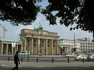 And as a sure sign that the wall has come down, right in the shadows of the gate is a ........
  Starbucks!
  Public spaces are much loved and used, and I was impressed to see how well the spaces are cared for and programmed. St. Stephens Green in the heart of Dublin, goes back to Medieval times.
  A local lord turned it into public park in the late 19th century. Its presence as part of the street grid is very interesting – the edges are filled with trees and shrubs that create a green envelope for the park.
  Once you get though this buffer, the park itself is a jewel. Graceful pathways, gorgeous water features, loads of history and amazing horticultural treats fill the park.
  Merrion Square is the grander public park, surrounded by Georgian homes, museums, upscale restaurants, and offices. one of Dublin's largest and grandest Georgian squares.
 The attractive central park features colorful flower and shrub beds, and a gorgeous lake in the middle. Much like St. Stephens Green, the park is hidden from its surrounds with thick vegetation, and is a treat to be discovered.
 Pheonix Park is a larger regional park in close to the city center. Its a beautiful bucolic landscape with rolling hills and expanses of meadows. Graceful tree lines mark the park boundaries.
  When Pope John Paul visited in the mid 1990's the giant cross was installed in his honor.
 The rolling meadows give a sense of expanse - its hard to believe that we are a few minutes from the city.
  We stop here briefly on the way to conference meetings, and I am tempted to get left behind!
 Since then the progress has been remarkable, including the relocation of the College of Ireland to a new, high tech ‘campus without walls’.
  It was great to walk around the area after listening to the city manager of Dublin and the head of the Development Authority paint the bleak picture of what existed before. Very impressive – and a great new connection to the river.
 Yet, the region is no longer the engine it used to be, and what was left are the industrial artifacts in the landscape.
 Bottrop is the location of the Tetrahedron, a massive steel sculpture that captures the ridge on a slag heap. As we get to the middle of the circle next to which the structure rises, I notice that there is a gentle and steady drop in grade to the middle. Michael explains that the designers intended for the person in the middle to view nothing else except the rim of the slag heap, the tetrahedron and the sky. I pause to stand in the middle of this vast circle of stone and view the sky all around me.
  In the far distance, I see a solitary figure crouching over the stones. When I ask Michael what the man is doing, he says, ‘You’ll find out when you climb to the top’.
  The Tetrahedron was built to reveal the landscape of the region to its people, and has become something that everyone is proud to visit and show off.
  The pictures illustrate this project much better than I ever will in words. In the night, the steel bars are lit in a special way and can be seen for miles around. As I start to climb, the landscape of the region emerges – smokestacks - some working and others not, train lines, massive steel structures, coal mines. It’s quite extraordinary.
 Michael mentions that the man picks out the lighter colored stones to create these figures and has been doing so for five years now. When we descend from the tetrahedron, we stop to talk to him - I am curious about the future. Michael says that he’s interested in expanding the martian family!
 The main administration building of the office complex is housed in the factory, and new bridges and pedestrian walkways connect various parts of the site together.
  There are open air theatres, rose gardens, a small daycare center, water fountains and large plazas, all used now by the office goers and nearby residents.
  A beautiful riverfront amphitheatre is being set up for today's concert.
  The remaining wall of an old factory building has been retained, and the landscape that has colonized next to it is fascinating to see.
  An old coal shaft is now the new entrance to the museum.
  I am taken by the harsh angles in the landscape, the vast meadows and sharply sloped walkways. The grades make for dramatic views of the old industrial infrastructure!
  The environmental issues in this area continue to pose huge challenges. I’m shocked to view the open sewer that still runs the length of the region. Its presence is a knife cut in the landscape, right adjacent to the clean waters of the Ruhr.
  Our next stop is at Zollverien, the best known site along this industrial landscape.
  The plant was closed in 1986, and today it is a UNESCO World Heritage Site. In its heydays, This colliery and coking plant produced 12,000 tons of coal and turned it into coke. Today, it’s a meeting point for cultural activities, and design professionals.
  The largest boiler house has been transformed into the Red Dot Design Museum by Sir Norman Foster. This museum is all about products that have been tested and given the ‘red dot of approval’ celebrating contemporary industrial, product, furniture and home designers. The site also houses local architects and designers in studios integrated into the old storage houses. A reflecting pool becomes a skating rink in the winter.
  When I look around I understand that there is an eco-exhibit and a meeting of the German Environment Ministry being held - there are lots of men and women in black suits and headphones buzzing around. Apparently it’s also an exhibition and conference center! I travel up the huge orange escalator to the main museum space – a Rem Koolhas signature piece.
